

the inevitable historical marker, packed with tantalizing bits of niformation


the view from the position of the marker,
the Confederate earthworks lie over the remains of the Spanish fort

the museum is on the right, more earthworks to the left

a commemorative plaque

the military cemetery

Inside the Museum

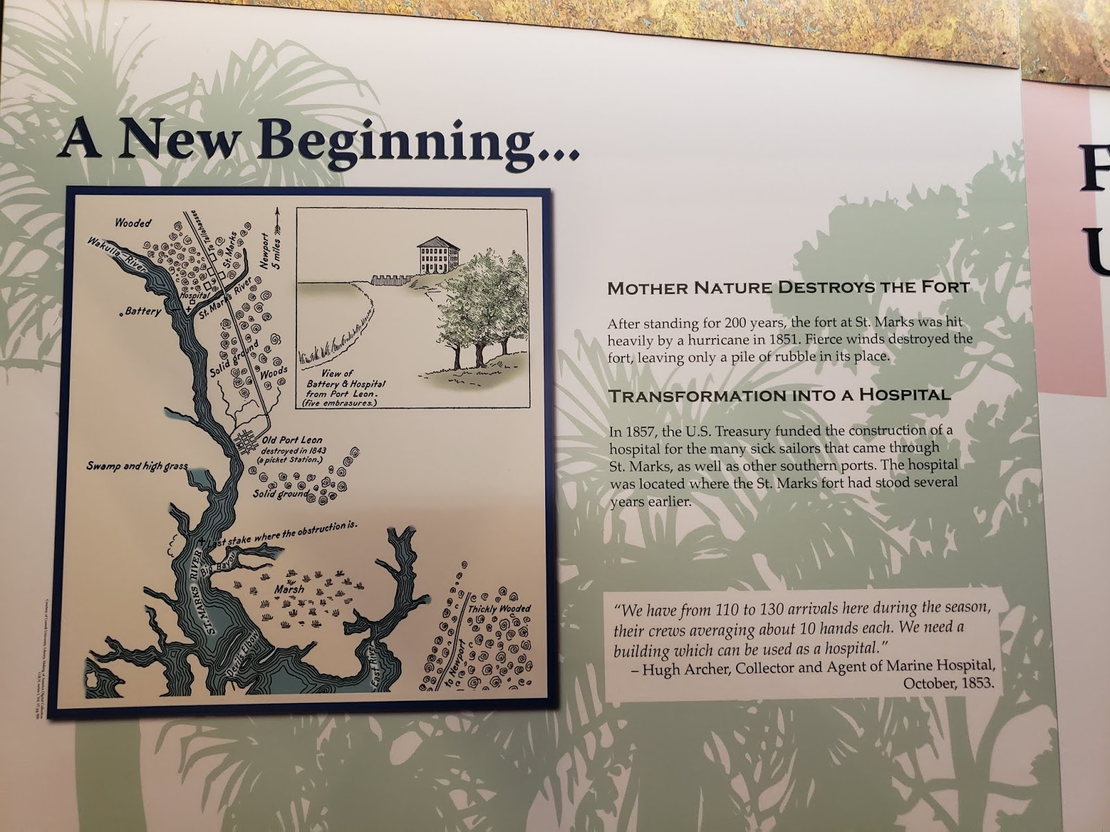
an interesting map showing the early fort and village outpost,
I was unable to determine if this was a representation of fact, or just a plan,
you get a feel for just how utterly flat and swampy the surroundings are

a double-bastioned wall facing landward complete with a glacis
protected the water battery and fort at the junction of the rivers

I wish that I checked to be sure that I had taken a clear photo of this
anybody who visits in the future please snap a better shot and forward it to me and I will replace this one, I have a friend that specializes in the colonial Spanish period and he can translate Old Castilian

an interesting aside from the fort, this Bowles fellow seemed quite a character

the first Spanish contact began in the early 1500's with the disastrous Narvarez Expedition

after marching though the hinterland and encountering an increasing degree of hostility
from the local population they decided to build boats to sail back to Cuba

a staggering amount of effort that ended in failure,
no trace remains of those who set sail

the parti-colored sail is because they used items of clothing to make it


a more specific model of what the boats are assumed to have looked like


various forts through the years, each one piled upon the remains of the prior structures


the museum has a very informative time-line
it is aimed more at the casual visitor than the military historian
but I learned a good many new things


I am still working on tracking down exactly how many different forts were built here; rot, insect infestation, pirates, hurricanes and formal enemy action all claimed at least one each

another tantalizing sketch, I only wish that I had a plan-form and dimensions


and, when they finally started to build in stone, the Spanish had to give it up to enemy

the British used the base as a trading outpost with the Native American tribes


a later map of the area

frustratingly inexact and clearly not to scale....

this is a period that cries out to be gamed

with the U.S. gaining control of the entire Florida coastline the fort fell into disuse
and the stones were re-used to build a maritime hospital


a model of the fort as it stood when the U.S. took control,
you can see the outline of the bastioned trace that the Spanish had planned long before
and the one bastion and portion of wall that they had completed

a drawing of the reverse side of the same position

and a plan-form drawing

I don't know the reason for the deformed eastern bastion in this drawing

a painting in the museum of the original fort constructed of logs
but painted white to look like the stone forts that the Spanish built elsewhere

stones from the original fort,
these had been recycled into the foundation of the Marine Hospital
and now support the museum


looking south from the museum,
the Confederate earthworks obscure most everything else

the Confederates filled in the Spanish moat
and built an earth and log wall along the north side of the moat edge

this was done to protect the back of the water batteries from attack from the north

the mound that you can see in the distance is the magazine,
the very high water table demands that you store your powder above ground-level

it is important to remember that at the time
all of this land would have been cleared of trees and underbrush

the park has clearly delineated paths and a pamphlet that provides addition information
and is keyed to markers on the grounds

the earthworks would have been substantially higher when built

probably another 3-4 feet


the earthworks encompass all of the original Spanish structures and a fair bit more land as well.

the magazine hill is deceptively large,
being hidden in the trees make it look smaller

but it is composed of a simple massive amount of dirt

some of the small amount of remaining Spanish walling

the low area in the center has the original Spanish wall to the south (left) and the Confederate earthwork to the right (north), this was the original moat

not much of an obstacle now
but it would have been more sharply defined a century and a half ago

careful examination shows that there was a significant ditch in front of the earthworks

views of the magazine hill


and down from the top

I doubt that anyone would have wanted to be in this exposed position in the event of a battle

particularly as they would have been literally sitting on top of thousands of pounds of gunpowder


looking south from the southern edge of the earthworks

the ground gets very swampy in just a few yards

looking west along the old moat from the top of the hill
Spanish wall on the left, Confederate earthworks to the right

the footpath follows the inner edge of the earthworks

looking up at the magazine hill from the south


as the path heads west from the magazine hill we get our first glimpse of the old Spanish fort,
some footings of the bombproofs that were located against the south side of the wall


there isn't much left after decades of the cut stone being robbed-out for other projects


you can just see the footprint of the foundations in the grass

the wall was almost a yard thick, made of the hard flint stone from upriver

a better look at the foundations


the Confederates used the stone walls and foundations
to support the earthworks and batteries that they build above


the foundations of the Spanish magazine

looking northeast from the inner southern face of the bastion position
the Spanish wall is to the right, the bright green grass is the old Spanish moat
and the rise in the distance is the Confederate earthwork

looking north from the same position

and northwest toward the river

straight west,
the Confederates built an earthen battery position atop the stone bastion
largely obliterating the footprint of the bastion

looking northwest again,
you can see the remains of the piles of earth that protected the Confederate guns

and a view south along the river from the battery position

panning north, you can see just how flat the countryside is


the earth rampart that entombs the stone bastion remains

looking east from the battery position toward the magazine hill
over what was once the Spanish moat

panning northward from that position


and back around to the river


looking really hard and using a lot of imagination
I could almost see the Vauban style bastion buried under the earth
this would be looking south east at the tip of the bastion,
the point would be bottom center and the faces heading off tot he right and left

another view of the old moat


the bridge is most certainly a recent construction

looking east along the face of the Confederate earthworks

and then west from the opposite end of the line
An intriguing site, deeply in need of a thorough-going archeological examination to illuminate its 400 years of history and deserving of a visit if you are in the area.
I really enjoy these Fortress tours; thanks for the hard work of putting together this post!
ReplyDelete