
the one that started it all; Daftrica
Ever since I was a child I have been fascinated by maps. The visual display of information that had been carefully compiled and the ability to plan activities from that information, the instantly obvious relationship between places and the artistry involved in the creation of them absorbed my young mind. I have collected maps from every place that I have been, bought maps of places I hope to go, culled maps from old issues of National Geographic. It approaches a disorder.
Maps of mythical places were not exempt from this collection. Howard's Hyboria, Tolkien's Middle Earth, or Burrows' Barsoom all had a place in my imagination. I enjoyed making maps of my own, recording places that I had been in my child's hand and then comparing the map I had drawn to a real map. My father explained that because it felt that I had "walked a hundred miles" didn't mean that the distance was really that far. He taught me how surveyors had made made maps in the past and befuddled my young mind with the maths involved calculating distances and heights.
When I got into wargaming I readily accepted that the maps in the Avalon Hill games of the 1970s were exact and accurate. Only later did I come to realize the compromises that graphic designers had to make to create a playable game surface.
This long-winded lead-in is just to lay the groundwork for a post on my way of making maps for the campaigns I run. A while back (twenty years or so) I drew up a map of a mythical continent that I made my loyal friends fight battles set in the period known as Pike& Shot. I ran this as a semi-solo campaign wherein I did all the bookkeeping and strategic planning and they took the place of the battlefield generals. They suffered through many games using George Gush's detailed and slow-moving rules until they finally rebelled and stopped showing up on evenings when such a game was scheduled. Not wishing to lose friends I set the campaign aside.
That is until now, having found the Liber Militum Tercio rules I am now going to re-launch the campaign. I went looking in my files and found that I no longer possessed the map (I think it was taken and destroyed by one of my disgruntled friends). Faced with this sad development I resolved to recreate the map. And just to show you how I do it I decided to document the process.


 next came cities, then roads and a start on place names

Behold the continent of Epicurea
a quick sketch-map drawn from memory

that map transferred onto a larger sheet of matte-board
mountain ranges make great natural borders and add limits on movement

the coastlines drawn in darker and with added detail
I let myself embellish the edges while glancing at maps of Nova Scotia

then the rivers run from the mountains to the seas
in high terrain they tend to run in fairly straight paths,
in flat land they often wander about a great deal

a splashy wash of Prussian blue to define the seas
I pressed the pencil quite hard when drawing the coast,
the slight depression make painting the edge of the coasts much easier

then I painted in the rivers,
this was a mistake as I then had to try not to paint over them as I added the other colors

a light brown wash to define the land areas,
keep the wash thin enough to see the pencil sketched details visible

this was followed by a medium brown paint applied over the hills using a stencil brush

higher elevations were added the same way using a darker brown

then the mountain peaks in a very dark Burnt Umber
if I had been contemplating very tall mountains the final bit would be white

fertile flat lands got a coat of light Hauser Green
sort of shocking but it tones down quickly as other details get applied

then I added the large areas of woodlands
using Dark Evergreen and a stencil brush

to add the farmlands I made stamps out of soft balsa wood
these were pressed into wet paint then stamped onto the map
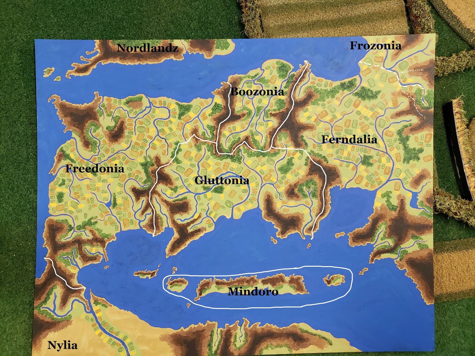
from there I took a photo and opened it in a graphics program to add the borders and place-names

the beauty of modifying a photo is that I can play with the look of the things
without committing brush to surface, this is probably close to how the final map will look
Now I just have to set up the armies and flesh out the back story and I can get things up and running again. As you can probably guess (if you read any of the place-names) this is a strictly tongue in cheek operation. Most of the story lines spin around providing opportunities for ridiculous names and bad puns. I intend to run the campaign on two levels; the grand battles will be fought using Tercio and the smaller actions will be handled using Pikemans Lament.
Very cool. Nice job on the map and creating your own continent. 😀
ReplyDeleteBrilliant mixture of media and techniques! This has tremendous for me, as an RPG DM... Thanks for sharing! Cheers!
ReplyDelete