
courtesy of Google Earth we have a top-down view of the fort
I recently had a chance to travel to the state of Tennessee and take in the glorious weather and the very well reconstructed Fort Loudoun. The park has an excellent museum and a friendly and well-versed staff. Built in 1756 as a trading post dealing with the Cherokee Nation it was the scene of a successful siege by the Cherokee who ended up in possession of the fort and it's twelve cannon. There is an excellent Wikipedia article here. This fort cleverly encloses the high ground that would otherwise overlook its interior thus avoiding the problems that Ticonderoga and Mackinac had when they were taken by opponents that captured hills looking down into those forts.

but once terrain lines have been added we can see that the regular trace of he fort is a carefully placed to take advantage of the hill to the northeast
The Fort Museum

signs on the approach to the fort museum


the sort of stuff I love, bold clear graphics.......

.....and recovered artifacts

as usual, the British found it impossible to get along with the Native Peoples


no doubt due to the exploitative mercantilism they practiced


Tellico Blockhouse, which was built as a fort/trade station by the newly-minted
United States in 1794 to "protect" the Cherokee from the aggressive settlers
(more on this later)

explanatory notes regarding the blockhouse

a very nice model of the blockhouse in it's heyday,
protected by the special "ultra-high-glare glass" that only museums have access to


an excellent display of the arms of the British

an interesting bit on the guns of the original fort, a group of school kids were listening to the Park Ranger speak and I didn't get a photo of the gun in question
(and I forgot to go back later and snap one)

the step-by-step of loading a cannon

an example of British uniform, it isn't apparent from the picture
but the mannequin was correctly sized for the period, about 5' 5" tall

the wall-gun was huge in comparison


an excellent model of what a bastion would have looked like while in use


a very crowded place to work


the renderings and artwork are top-notch

comparison to other contemporary forts is shows how
the bastioned trace was adapted to suit the local circumstances


I particularly like it when the include the source material

and then go and build an absolutely fabulous model!

I managed to get around the the high-glare protective glass by convincing a Korean couple (who spoke as much English as I speak Korean) to hold up their jackets to block the lights
thank-you to you lovely people, whoever you are!

their kids were fascinated by the model


and then they just walked away
(no doubt wondering about crazy Americans taking pictures of the model
when the real thing is just 100 yards away)


another period era mannequin

DeSoto also passed through these parts

I can't imagine wearing that sort of stuff in a Southern summer!


the poor dog!


Tellico Blockhouse was built on the opposing ridge about a half century laetr

barely visible on the opposing slope
The Walk-Around
The letters indicate the approximate location where I stood when I took the picture


approaching the fort from the northwest
Point A


moved to Point B


a bit closer to the corner

the slope isn't quite a cliff but it is VERY steep

I would not have wanted to try to climb up that under fire

moving to Point C

the steepness of the hill becomes apparent


moved to Point D


the shift in the color of the palisade is where the indent in the wall occures


moved to Point E
you can see the way that the fort climbs the hill to encompassed the overbooking ground
that would have rendered the fort untenable if possessed by the enemy 
moved to Point F


taking a closed look at the hedge and ditch


a look along the ditch, the thorny hedge looks unimpressive but would be a significant obstacle if you were to attempt passing through it in an assault

moved to Point G


moved to Point H
a placard about the local Native Americans


moved to Point I

another view that demonstrates how the fort enclosed the overlooking high ground


the sentry box at Point J


looking uphill, in places the slope is approaching forty-five degrees!


just a reminder that in the days that the fort was in use there was a small river in the bottom of a gentle valley, there lake is the result of activities in the 1970's to control flooding and generate electrical power


moved to Point K
at the foot of the hill

struggling up the hill toward the point of the bastion

looking downhill from the point of the bastion

and along the northern face of the fort

moved to Point L


and finishing up at Point M

The Interior
The numbers indicate the approximate location where I was standing where I took the picture


Point 1, just inside the sally-port, a look to the left

scanning across the interior, notice the steepness of the hill

looking straight down the slope, the good reader will remember that the lake was actually a
valley with a small river running through it at the time of the fort's occupation

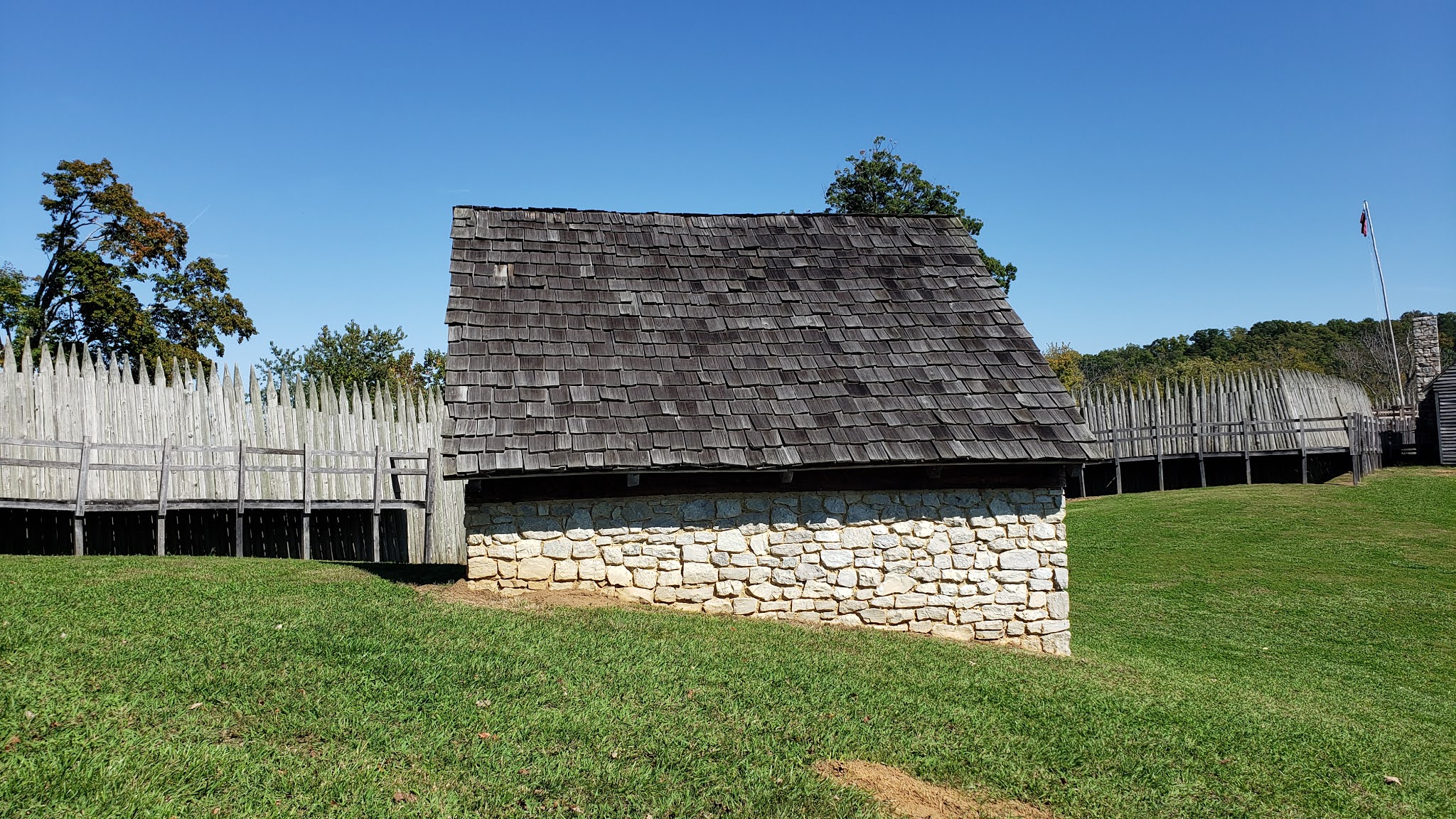
further to the west we find the magazine

last we look straight along the wall to the right

from Point 2, scanning counterclockwise, looking back at the sally port

further along we see the magazine

and the northern end of the Long Barracks

the stepped foundations are each about three feet tall on the high end

at the far southern end the ground finally levels off enough to allow a longer barracks building

looking straight down toward the main gate

looking southeast toward the blacksmith shop and bastion

and then the officer's quarters, again notice the slope


at the top of the hill the base commander's house


looking north at the firing step inside the pallisade

and back to the sally-port

Point 3, the magazine

the front (and only) door

walking around

strangely thin door for a magazine

I am willing to bet that it was better stocked than this


although I would be happy if those muskets were in my magazine

Point 4, the northwest bastion

a replica of one of the twelve guns that the fort had


looking back into the center of the fort

and south along the western wall

peeing out the gunport

looking east along the inside of the north wall

looking south


Point 5, looking straight south along the west wall

Point 6, the southwest bastion


the deck is made up of four inch thick planking

the gunports seem oddly large


the alternating long and short pales create crenelations that would permit muskets firing from the wall

scanning north to east across the interior


another small cannon, these were brought in on the backs of pack horses

the hedge provides no cover for attackers but offers a substantial obstacle

a defending soldier's view of the hedge


Point 7, the southern gate


the trader's warehouse

looking north from the main gate


 |

Point 7a, defenses outside the main gate


Point 8, no tents, the re-enactors were not on duty when I visited,
looking east along the inside of the south wall
the blacksmiths shop with the well in the foreground


close up of the well


the blacksmith's shop, as far as possible from the magazine


Point 10, the southeast bastion


looking north up the eastern face
(and uphill!)

Point 11, a barracks block


seriously one-star accommodations

the interior


I do like the stone fireplace
but I think they could do more with the interior decoration

Point 12, the bread oven

or, less likely, a brick pizza oven


Point 13, looking south from just inside the eastern sally port

scanning across the interior


the officer's quarters


looking up the inside of the eastern wall

it is very steep, I can't imagine climbing this in 18th century kit

even the officers lived in spartan circumstances

Point 15, the trader's warehouse near the main gate


inside of the Trader's warehouse


Point 16, the western barracks

barracks interior


looking uphill from the south end of the barracks

looking south from the top of he hill
Great pictures John. Tennessee has a health of Forts and Battlefield. Looks like the weather was perfect.
ReplyDeleteA very interesting site; thanks for the tour!
ReplyDelete