
This last week found me taking a 3000 mile road-trip to the southeastern portion of the good old US of A; having discharged my responsibilities I found myself with a bit of free time so I swung by the swampy coastline of Georgia for a visit to Fort King George for a some photo-survey action. This little establishment was founded by Colonel John "Tuscarora Jack" Barnwell tocreate a British claim to Georgia (the Spanish had inconveniently claimed the area a couple of hundred years earlier but had done little to enforce that assertion). Taking note of previous Spanish objections to other nations establishing
colonies on land that (on paper at least) belonged to the King of Spain
(the French effort came to a bad end) the British built a fort and garrisoned it with an Invalid Company (soldiers that due to age or infirmity were no longer fit for field operations).The longstanding inability of the British to get along with the native
inhabitants of the continent argued for a fort as well. The result was
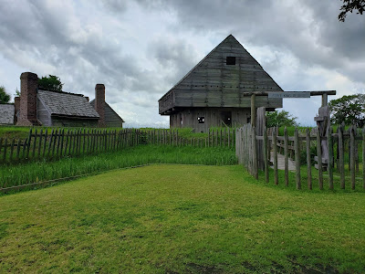
this intriguing little establishment. After the fort was abandoned Sir George Oglethorpe established a colony called Darien at the same location. Having learned from the previous foolishness at Jamestown that there were not any mounds of gold to be dug the practical Sir George Oglethorpe sent them to harvest the obvious natural bounty of the land; timber. The first thing that the settlers did was to fortify their colony, but this time they chose Saint Simon's Island for their Fort Frederica. There is a pretty good history of all these events available on Wikipedia.
The map you see below will give some context top where the pictures were taken, locations are not exact but should serve to provide the viewer with some orientation as to what direction they are looking and where from.


 the blacksmith's shop


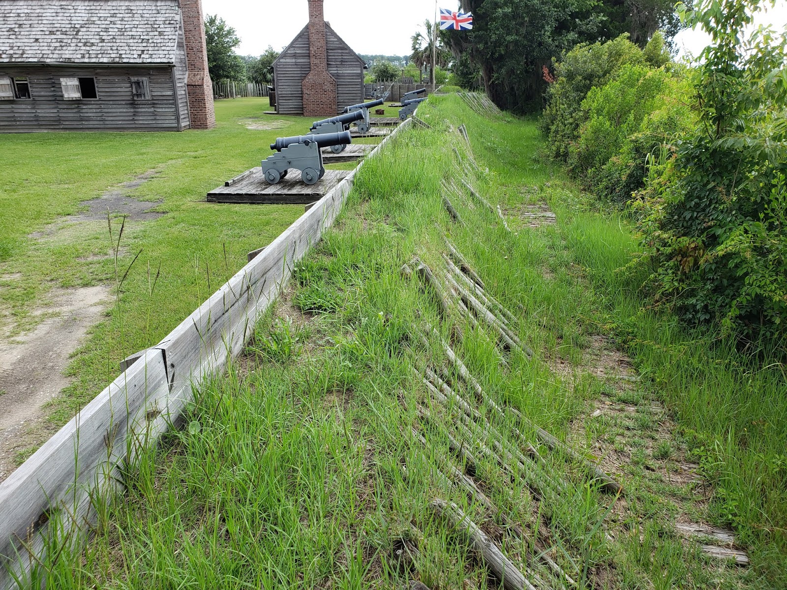
 looking northwest along the northeastern flank of the bastion


Officers Quarters


 another little wall-gun,


the locations are in the order that I stopped to take pictures, I did not venture out the gates on the western or southern side of the fort as the staff advised me that a rather large alligator had been seen in the area just recently and I had left my sidearm in the car
Photos from A

who needs a moat when you have a marsh full of 'gators?

the inevitable plaque showing the park,
this one is actually pretty good

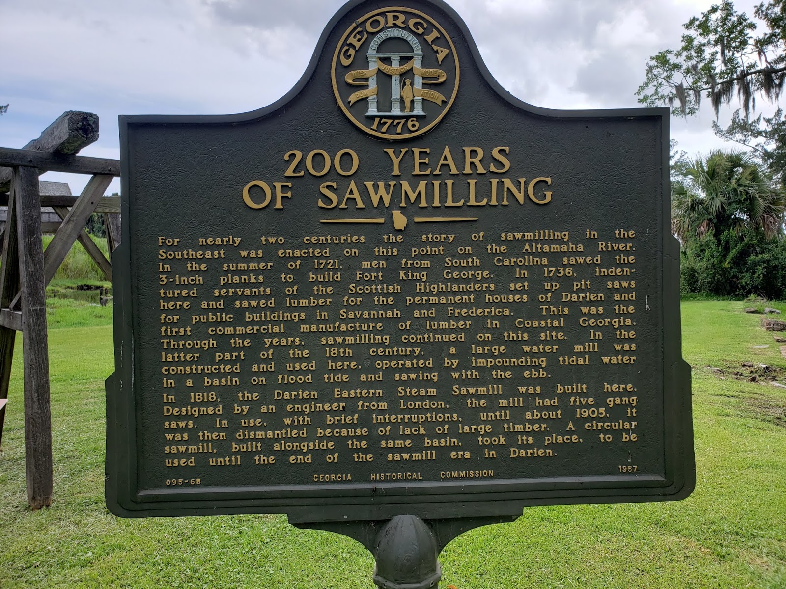
ruins of the tidal-powered sawmill

the Georgia clay makes decent bricks,
these are over a century and a half old
another plaque, it is self-explanatory


native huts were made from wattle and daub,
the universal building method for simple structures,
this would normally have a thatch roof

an old millstone

the walkway across the swamp,
position A on the map for photo reference

looking southeast across the old millpond

Heavens! another plaque!

looking very nearly straight east from A
toward the front gate

a few steps closer

at the other end of the bridge
I love the little wooden guardpost

looking south from the end of the bridge,
I would hope that the garrison would have kept the grass cut,
it was nearly five feet high at the time of my visit
Photos from B

looking straight south from B
the weedy line on the right edge of the picture is the moat
if you didn't know it was there you wouldn't notice it until you were in it

ruins from sawmill operations
they are from an era after the fort passed from use

by the way, stay off them!

the gate and bridge,
the flimsy looking picket fence is largely on the inside of a six foot deep moat and,
as such, would present a significant barrier to entry

looking southwest from B

straight south, the blockhouse is very imposing

another view of the main gate

looking east ,
this position is covered by two small wall-guns located on the parapet

closer

the far northeastern end of the fort
this is where I was cautioned by park staff of several large alligators
that had been seen a short time before

looking southeast toward the wall

the gun port with the wall gun

the entire area was covered by the musket and cannon ports of the blockhouse

the picket fence is sunk several feet into the ground and is surprisingly sturdy

the gate is simply massive, the planks are over 4" thick and the beams even thicker

I always wondered if they really hung up such signs,
it isn't as if there was another nearby fort that might confuse a visitor

on the bridge past the gate looking west along the moat

the view to the east. if you look carefully you will notice that the moat is
lined with planks to keep the sandy soil from subsiding into it
Photos from C

I might just build one of these for myself and put it in the corner of my garden

the earthen parapet is also lined with planks to hold everything in place

the wall is high enough to provide cover if you are off the firing step (and under about 6'6" tall)

the lower floor musket ports overtop the wall as well

back in the day there was a ladder to the door
instead of this OSHA approved stairway

the planks of the blockhouse are at least four inches thick

looking east along the inside of the parapet

a closer look at the wall gun

cannons from the blockhouse could fire directly along the gateway appraoch

that benign looking moat,
plus there might be snakes and alligators in it!
Photos from D

the weather and insects pose a constant threat to the wooden structures

view from the guardhouse, looking west

north

and east

looking east from the platform just outside the guardhouse

the blockhouse from the same spot

south-southwest from the same spot


straight west

northwest

and back north from slightly further along the wall walk
Photos from E

northeast at the blockhouse, the cannon were positioned to sweep the glacis

straight east

looking southeast along the water battery

a view along the wall southwest toward the next guard post

while the fort was in operation the trees and underbrush were al cut away

straight west

and back north at the first guard house

to the northwest

to the west from the corner of the bastion flank

the southwestern guard post


it has a much fancier approach the the first one we visited
straight east along the top of the water battery on the southern face of the fort,
in an effort to deter erosion the outer face was covered with wooden pales


the blockhouse with the Officers Quarters in the background

the western gate
which does not appear on period maps

looking north from the guardhouse steps

the moat is nearly invisible

another look at the water battery

a wood paved walkway is at the foot of the parapet

the blockhouse with the historical mode of entry

another look at Officer Country
Photos of the Battery

the water battery faced a hair-pin turn in the river

no information was provided as to the make and caliber of the guns,
I have to assume that these are simply representative
as cannon in the 1720's were often used on field carriages

this appears to be more along the mines of a carronade

again, the underbrush would have been cut to allow a better view


an idea of the narrow constraints of the river


a better view through another gunport

the water gate, this also does not appear on the drawings that I have seen

a closer look at the logs laid against the face of the parapet to stem erosion

looking east into the water gate

and looking west from the same location

looking in through an embrasure

a cute little coehorn mortar


Photos from F

the watch tower near the slipway for the watch boat

note the sand eroding between the logs of the parapet,
this was a constant problem for the garrison and still is one for the Parks staff

the palisade surrounding the watch boat

the watchboat


this area must have proven to be a weak point in the defenses


looking west into the interior of the fort


an outdoor workshop, the stifling heat must have come as a shock to the British
Photos from G

looking east into the interior from the water battery,
the open-framed structure in the left distance is the bakery

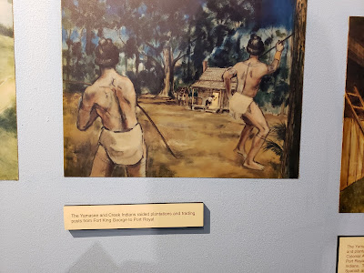
huts for indigenous tribesmen and slaves

primitive, to say the least


there was a lonely little 3lbr on a late 18th century carriage in one of the sheds

it looked so lost and sad that I wanted to load it up in the truck and bring it home

unfortunately the Parks staff demurred

even after I promised to take care of it and bring it back when they needed it


Photos from H

the eastern gate, again this does not appear on the drawings that I have seen
but does appear in the very nice model in the museum

the Parks grounds crew were part way through rebuilding the base of the watch tower

the bakery was outdoors and away from the other buildings

quite a way away from the other buildings

the interior looking west

I guess you could call it a parade ground but,
with only 100 men stationed here, that might be a bit grandiose

looking south at the loo

the bread oven was stoutly built

as was the shed that contained it

a look west along the parapet

one of the pivot guns,
given the length of the tiller at the back reloading would seem problematic


it covers the main gate quite nicely

a hovel next to the Officer's Quarters

a closer look at the chimney of the Officers Quarters

peering westward between the Commandant's House and the Officers Quarters


the other pivot gun has an even better view of the front gate

looking northwest from the northern flank of the bastion

and then back east along the parapet

looking east along the outside of the works,
if you look closely you can spot the moat

this pivot gun has an excellent field of fire along the moat as well

The Commandant's House

it faces south


and has a very substantial hearth

not very luxurious accommodations


the western face of the Commandant's House
Officers Quarters

the western side

the southern end

detail of the window and hinges


this fancy outfit has two doors!

and two very impressive fireplaces

the interior is Spartan

but at least they have proper cots


the equivalent of a "footlocker"


plenty of room on the mantle for steins and mugs


looking at the northwest corner of the Officers Quarters
The Barracks

the western end

the side facing out over the water battery has only windows which overlook the glacis

detail of the window and the cedar shake shingles


chimney details

only two doors, both facing the parade ground

looking back out at the Officers Quarters

both fireplaces are large and well made

the building served as a barracks and a chow-hall

this place looks like it is only getting one star from Michelin


detail of the inner roof framing

the northern face of the barracks
The Privy


that would be some crowded circumstances

In the museum

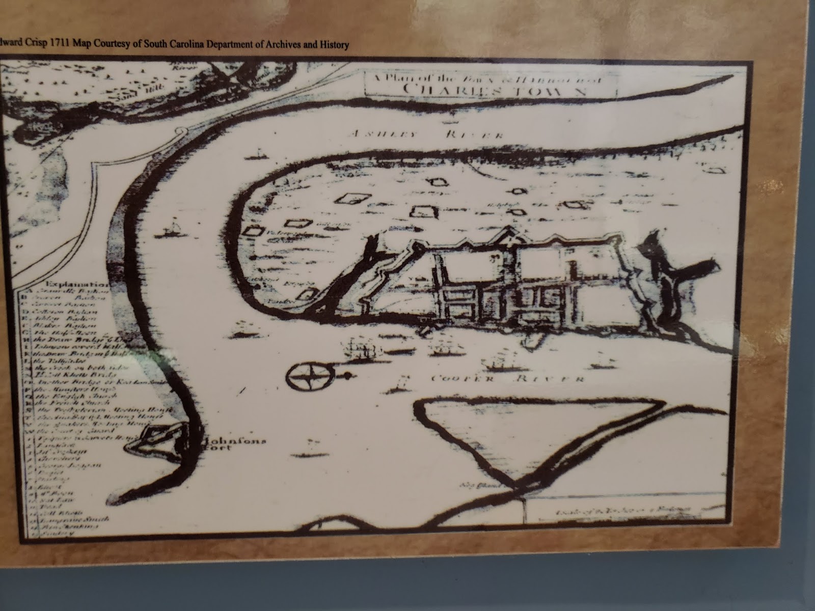
there are many maps and drawings of the fort,
none of them agree exactly on how it loked


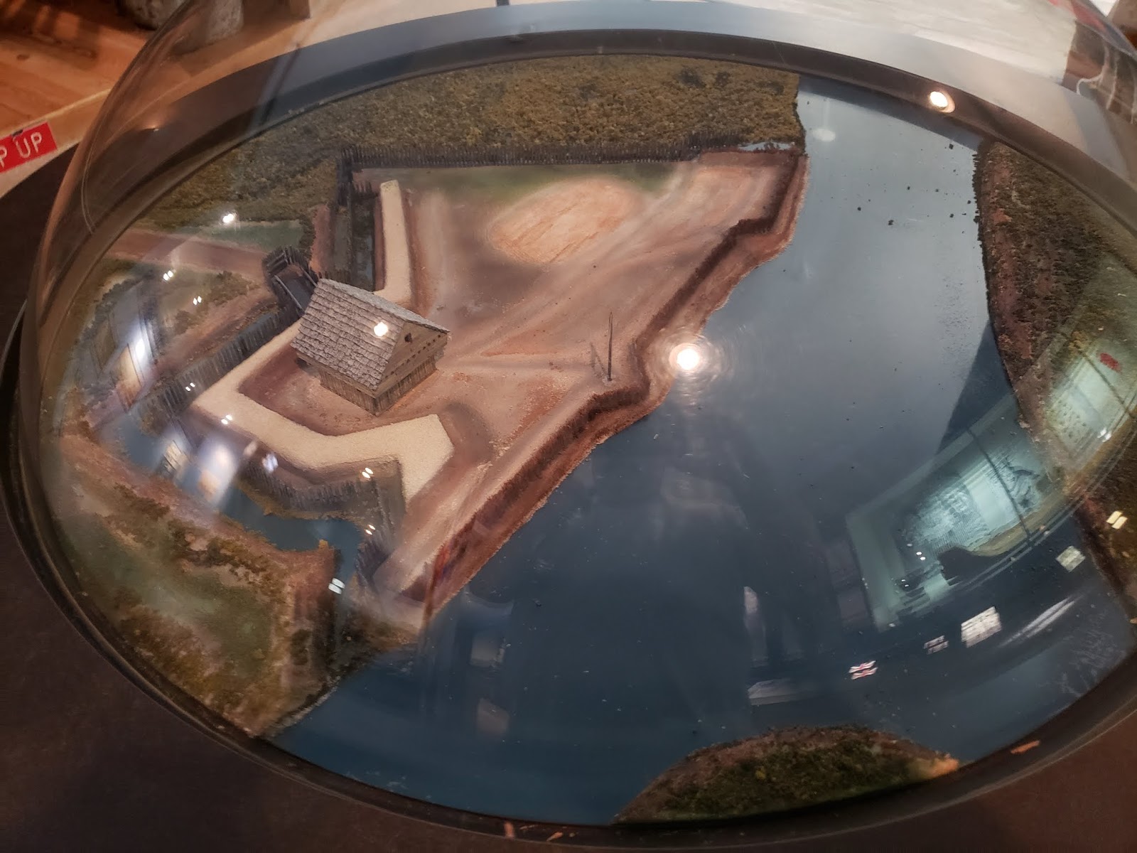
the special "museum-only" ultra high glare glass makes another appearance


the last thing in the world that I would want to face is an angry Scottish woman with a cannon!

a beautiful little model of the fort under a dome of the high-glare glass


a Spanish soldier ca 1700AD


this map gives a good idea of how the fort could obstruct the movement of boats on the river


a lovely larger model (roughly 1/30th scale) of the fort buildings


a nice "as built" vision of the fort


an English soldier @ 1700AD

this one is real

paintings in the video room


some nice uniform displays rendered almost impossible to photograph by the glass reflections


a Scottish soldier @1720AD

I have to think that the point on a targe was smaller than that


King George I
Well worth a visit, it is also close to Fort Frederica and the forts in and around Savannah.
What a great site/museum. A very small part of history excellently preserved. Thank you for the write up.
ReplyDeleteGreat pictures. Interesting Fort and awesome notes.
ReplyDelete